Output Choices:
- Large JPEG
X3D
(For X3D plug-in information click here.)
You have chosen to view:
Output Choices:
X3D (For X3D plug-in information click here.) |
You have chosen to view: |
Click here to view Map Legend
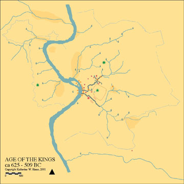
This map represents the changes to topography and hydrology within the intramural city, as well as hydraulic innovations instituted during the Age of the Kings (ca. 625 - 509BC). The landscape was dramatically transformed by the construction of a large drain called the Cloaca Maxima. This drain collected the waters from the living stream, refered to as the Forum Brook, which flowed into the valley between the Palatine, Quirinal, and Capitoline Hills, thus drying out the seasonally marshy area that was later occupied by the Forum Romanum. "Living water", that is the water flowing from a natural spring, was considered sacred and was not included within the newly constructed protective walls that surrounded the plateau of the Palatine hill. Another drain, the Cloaca Circus Maximus, was constructed during the "Age of the Kings" in order to drain the area to the south of the Palatine where games were held. The first bridge across the Tiber River, the Pons Sublicius, was constructed during this period.
To learn about any feature, open the map in JPEG, then click on the feature. This will link to an inventory entry with descriptive text, images, historic texts, archival maps and images, and to a bibliography. The complete inventory for most features is still under construction.