Output Choices:
- Large JPEG
- X3D
(For X3D plug-in information click here.)
You have chosen to view:
Output Choices:
|
You have chosen to view: |
Click here to view Map Legend
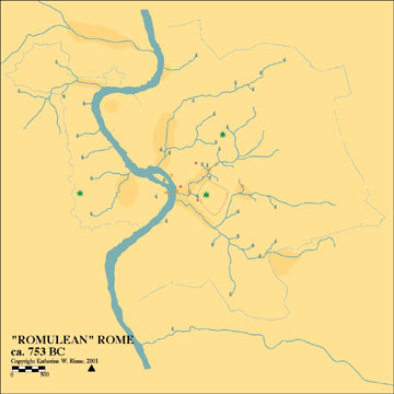
This map represents the hydrological landscape of the intramural city as it might have existed during the time of Romulus, the mythical founder of Rome. Tradition dates the founding of the city to 753 BC. The major hydrological and topographical features at that time were: the Tiber River and its island; the "seven hills" which surrounded the area that would later become the Roman Forum; the seasonally marshy areas found primarily near the Tiber, but also as far inland as at the future sites of the Pantheon; the Colosseum and the Roman Forum; the streams that had carved deep channels as they flowed down from the hills to the Tiber River; and the numerous natural springs that provided fresh drinking water. According to Cicero, Romulus chose this site because it was "rich in springs". Maintaining the purity of the springs required construction of some type of protective element. This would have constituted one of the first civic acts of the new Romans.
To learn about any feature, open the map in JPEG, then click on the feature. This will link to an inventory entry with descriptive text, images, historic texts, archival maps and images, and to a bibliography. The complete inventory for most features is still under construction.