Output Choices:
- Large JPEG
- X3D
(For X3D plug-in information click here.)
You have chosen to view:
Output Choices:
|
You have chosen to view: |
Click here to view Map Legend
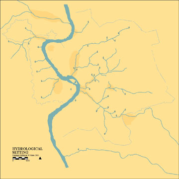
This map represents a composite of data drawn from archaeological, geological, historical, and literary evidence concerning the hydrological structure of the intramural city and its immediate surroundings. It does not represent a specific point in time, but rather represents an amalgam of hydrological features, most of which have been known since antiquity. However, water is dynamic and therefore constantly changing. Springs can disappear, dry up entirely, or reemerge at a different, sometimes distant location. Streams and rivers can change course, and the profiles of their beds are constantly changing as well.
To learn about any feature open the map in JPEG, then click on the feature. This will link to an inventory entry with descriptive text, images, historic texts, archival maps and images, and to a bibliography. The complete inventory for most features is still under construction. All features can be viewed against contemporary (1998) topography drawn at one meter intervals, or against the contemporary (1998) street plan.